
After another slow week a lot of work has nevertheless been done to get the mosaics of Springfield finished and imported into the GIS. This has now been completed and adjustments are being made as needed to the maps to address any changes needed.

Using the 1976 aerial images (official New Zealand Railways survey of Springfield) this is the detail of both stations. The main improvements for the Springfield maps have been to use the newest high resolution background aerial images for Selwyn District at 0.075 m pixel resolution for improved accuracy and provide aerials for 1943, 1960 (part), 1965, 1976 and 1982 so as to have the most generations of historical imagery from the Crown Aerial Film Archive. As with the maps of the Midland Line before this point, the maximum available level of relevant imagery from Linz Data Service webmail tile services will also be utilised when the maps are produced. At the moment only perhaps a couple of hours of checking is needed to be able to push out the Springfield maps and this is expected to be completed in the next day or so.
The rest of the Midland Line as far as Otira is imminently close to completion. There will be no revision of any content from Kowai Bush to Arthurs Pass; this will be done later. As part of the Arthurs Pass and Otira station maps, the scans from Archives New Zealand for the proposed switchback railway over Arthurs Pass have been located and will be added to the maps. This is also close to completion, including the addition of historical aerial imagery of the highway and the general appearance of the route as it was in 1938, when the first known aerial survey of the route over the summit of Arthurs Pass was flown. At this stage there is still a strong commitment that every effort will be made to complete the maps to Otira within the next three days whilst acknowledging the work is running behind the planned schedule.

Part of the route of the Arthurs Pass highway as seen in 1943, the well known “Zigzag” (bypassed in the mid 1990s) is prominent in the centre. The route proposed for the switchback railway, to be worked by the Abt system and with gradients of a maximum of 1 in 15, was to have come down the opposite side of the river valley from the road, but would have crossed over just to the east (rightward in the above) of the zigzag where a station called “Kopeki” was planned. This point is one mile below the summit on the Otira side of the pass. The route was around 10 miles long with seven miles on the Otira side and three miles on the Bealey side; this reflects the height difference between the two townships which is reflected further in the steep gradient of the Otira railway tunnel.
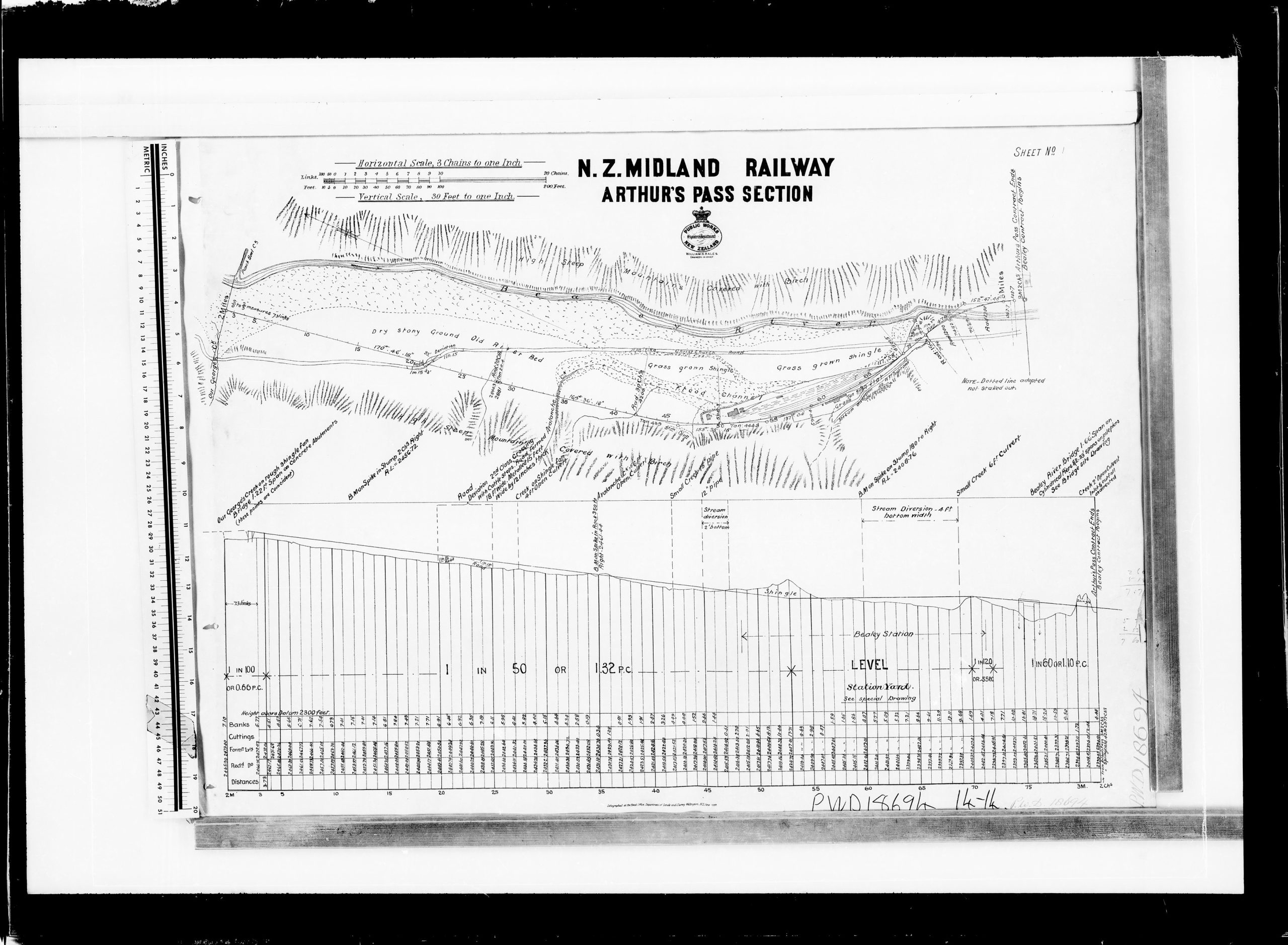
Plan for the 2 mile to 3 mile section (measured from the summit) of the switchback railway on the Bealey side of Arthurs Pass. The location chosen for the Bealey railway station is quite similar to where the temporary terminus Arthurs Pass station was built when the Government took over construction of the Midland Line from the MRC and brought the railway through from Springfield in 1914. Also note that the railway is shown crossing over to the north side of the Bealey River – the route then planned for the railway was different from what was actually built, whereby it now crosses over further east at Bealey Bridge instead after coming up the valley from Cora Lynn and the Waimakariri River Bridge.